|
The Peaks Metals &
Mining Technology Company & The Ministry of
mining and Industry of the Government of the
Islamic Republic of Mauritania signed agreements
in December 2006 by issuing license to the
company for conducting scientific explorations
for Gold, Base metals and Iron in four licensed
areas in the republic of Mauritania within a
period of three years from December 2006.
|
License No
|
Metals
to
be explored |
Location |
Area |
|
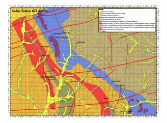
335 |
Group2*- Metals
|
Bou zraibia in Assaba and Gorgol in Al Brakna regions
|
1486
Km2 |
|
336 |
Group2- Metals
|
Ta in
Trarza and Adrar regions |
1482
Km2 |
|
337 |
Group2- Metals |
Midneth Al sabath in Al Adrar and
Inchiri regions |
1462
Km2 |
|
338 |
Group1*-
Metals |
Arghin
in Trarza and Adrar regions |
1486
Km2 |
|
TOTAL AREA |
5716
Km2 |
Group 1:
Iron Ore.
Group 2:
Gold and
Base metals ( Non ferrous metals excluding
Precious Au, Ag, Pt Metals) These include
Copper, Chromium, Aluminum ,Lead, Zink, Nickel,
Tin ,Rare-earth elements etc.
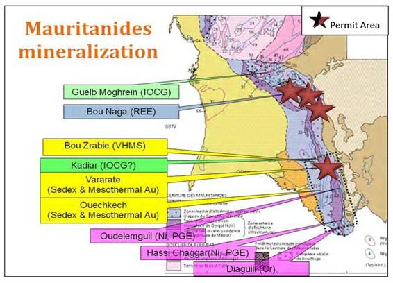
All the company
licenses areas fall within the NEOPROTEROZOIC
N-S striking Mauritanide Belt. The Mauritanide
Origin is one of the West African fold belts.
Largely ALOCHTHONOUS, the Mauritanides rest in
abnormal contact on the crystalline terrains of
the REGUIBAT shield and the platform cover of
the TAOUDENI Basin. Many gold and copper
prospects extend along the length of the
southern Mauritanide origin.
The Mauritanides
Range, as such extends between the latitudes of
15° and 20° N and the longitudes of 12° and 15°
W. It is a long belt extending from the Western
Sahara towards in the north, up to Sierra Leone
in the south, extending through western
Mauritania and the eastern part of Senegal.
In the west, the
Mauritanides bound the West African shield. They
consist of strongly folded and tectonised
sedimentary and metamorphic formations, deformed
during the Pan-African, Caledonian and Hercynian
orogenic events. It contains the Akjoujt copper
and gold deposits, and many other copper, gold
and chromium occurrences.
Four large
structural zones are distinguished, generally
bounded by tectonic thrust contacts following a
sub meridian strike:
ØAutochtonous
ØParautochtonous
ØMedian Zone
ØIntermediate
Zone
Inventory of
existing Data and interpretation
GEOLOGICAL DATA
GEO
PHYSICAL DATA
EXISTING REPORTS
BOREHOLE DATA
AERIAL PHOTOPOGRAPHS
SATALLITE IMAGES
 GEOLOGY
MAPS GEOLOGY
MAPS
TOPOGRAPHIC MAPS
Ask us About
MAURITANIA for:
1. State Policies in
mineral development sector.
2.
Institutional structures and their
responsibilities.
3. Planned,
completed and ongoing activities in mineral
resources development and mining sector.
4. Types of
available geological, geographical and other
scientific information and data.
5. Reports on some
ongoing mining activities.
6.
Reliable
recommendations for future explorations.
|